Tubuai

..

Tubuai is located south of Tahiti, offering a cooler climate for holidaymakers.

The Tubuai group includes Rimatara, Rurutu, Raivavae and Îles Maria, part of the Austral Islands in far southwest French Polynesia.

The Austral islands are a great art area in the South Pacific.

Artifacts include sharkskin drums, wooden bowls, fly whisks and tapa cloth.

Tubuai has a population 2200 people.

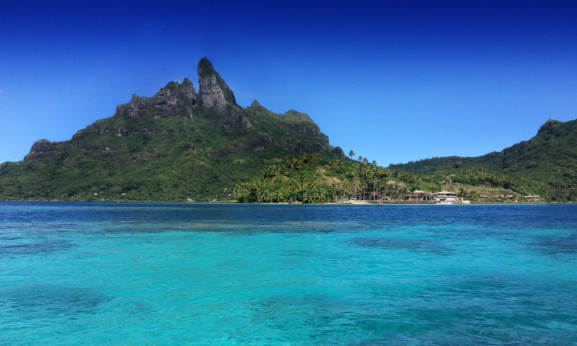
The island is ringed by a lagoon and encircling barrier reef.

A break in the northern reef enables passage for ships.

The barrier reef creates a lagoon of 85sqkm, up to 5km wide.

Because it is shallow it is usually bright turquoise or jade in colour.

Eight offshore islands surround the main island.

Tubuai has two volcanic domes, with Mt Taita’a being highest at 422m.

Seven islets (motus) are located on the reef that encircles the island.

Captain James Cook learned the island’s name when natives surrounded his ship in canoes in 1777.

The next Europeans to arrive were HMS Bounty mutineers, in 1789.

A conflict arose while the mutineers were still on the ship and islanders were killed in their canoes.

The location is now called Bloody Bay.

The climate of Tubuai is cooler than Tahiti, with temperatures averaging 20–25C. The lagoon waters typically reach 26C in summer but only drop a few degrees in winter.

The humidity is lower than Tahiti, which appeals to some prospective visitors.

Check out the island’s accommodation at booking.com


Taha’a

Taha’a and neighboring Raiatea are enclosed by the same coral reef in the Leeward Islands, part of the Society Islands in French Polynesia.

The two main resorts of Taha’a are both on their own islands, offering both luxury and affordable holiday accommodation.

Le Taha’a Private Island and Spa is one of the most luxurious resorts in the Tahiti region.

Located just off Taha’a in a lagoon surrounded by white sand, it has spectacular views of both Taha’a and Bora Bora.

In the middle of the lagoon is Vahine Island Private Island Resort, which has gleaming white beaches, three over-water bungalows, and six beach bungalows.

La Pirogue Hotel is on a private island in the north of Taha’a. It has nine bungalows.

Taha’a island itself is scenic, reaching a height of 590m.

It produces up to 80 per cent of French Polynesian vanilla.

It also produces pearls of exceptional quality.

The administrative centre is the settlement of Patio.

Taha’a and its small islets can be reached by boat and outrigger from Raiatea.

These parts of the Society Islands are less modernized, but the resort on Vahine Island is globally regarded as an exclusive getaway.

Check out the island’s accommodation at booking.com

Tahaa has a perfect combination of white sand and crystal clear water. Picture: Kat Kellner/flikr
Taha’a’s white sand and clear water. Picture: Kat Kellner/flikr


Raiatea

The spectacular profile of Raiatea. Picture: clr_flkr/flikr
Maori dancing at Raiatea. Picture: Alessandro Caproni/flikr

..

Ra’iātea is the second largest of the Society Islands, after Tahiti, in French Polynesia.

A traditional name for the island is Havai’i, homeland of the Māori people.

The Māori of Aotearoa regard this place as a sacred marae of their ancestors.

The main township on Ra’iātea is ‘Uturoa, the administrative centre for the Leeward Islands.

There are colleges for students from the regional islands of Bora Bora, Taha’a, Huahine and Maupiti.

The extinct Ulieta bird originated from this island, along with other unknown species, there is only one drawing of it, in the Natural History Museum London.

The islands of Ra’iātea and Taha’a are both enclosed by a single coral reef.

Ra’iātea is the largest and most populated of the Leeward Islands, with a land area of 167km2 and 12,000 inhabitants.

The first European to sight Ra’iātea was Pedro Fernandes de Queirós in 1606.

The Polynesian navigator Tupaia, who sailed with explorer James Cook, was born in Ra’iātea around 1725.

Cook visited Raiatea in 1769 and again in 1773-1774.

King Tamatoa VI was the last monarch, reigning from 1884-1888.

Ra’iātea has a small road that runs around the entire island.

Ra’iātea Airport is an airport in ‘Uturoa.

There is less tourism compared to other islands in the archipelago. There are two marinas, a four-star hotel The Hawaiki Nui, and a port for cruise ships.

The economy is mainly agricultural with exports of vanilla, pineapple and coconut. Fa’aroa Valley cultivates vanilla, and pearl farming is an important industry, while the farming of cattle, sheep and pigs has decreased.

Check out the island’s accommodation at booking.com

Rangiroa

The pier at Kia Ora Resort on Rangiroa Atoll. Pic: Dany13/flickr

..

Rangiroa is one of the largest atolls in the world.

It is part of the Palliser group, 355km northeast of Tahiti.

Its nearest atoll is Tikehau, 12km to the west.

Rangiroa is home to about 2500 people. The chief town is Avatoru. Only two islands, at the northern end of the atoll, are permanently inhabited.

The atoll consists of 415 small islands and sandbars with a land area of 170 km². The atoll is 80km in length and from 5km to 32 km wide.

There are about 100 hundred passages through the fringing reef.

The lagoon reaches 35m deep and is so large it has its own horizon.

Rangiroa is a major diving destination because of the lagoon’s clear blue water and impressive marine fauna.

During the 1950s, the economy of Rangiroa was driven by fishing and and copra production. The building of Rangiroa Airport in 1965 allowed development of tourism.

Breeding of pearl oysters in the lagoon has produced black pearls.

These pearls vary from white to dark are the only cultured pearls with so many different natural colours.

Pearl farming is done in more than 30 atolls of French Polynesia.

Rangiroa is also known for vineyards, which are unique. The vines grow on the edge of a lagoon beside coconuts, and produce two harvests a year. The winery is in the heart of the village of Avatoru. The first vines were imported in 1992. The vineyard is Domaine Dominique Auroy.

For divers, Rangiroa has some of the best dives in the world in and around the Tiputa Pass, which lies at one end of the one main road and runs 3.5km to the Avatoru Pass.

When the tidal current is flowing inward through Tiputa Pass, about 200 sharks gather at the entrance to the Pass, at 50m deep.

The sharks can remain motionless. Large manta rays, green sea turtles and humphead wrasses can also be seen. In January, large number of stingrays gather in the Tiputa Pass, as well as hammerhead sharks that feed on them.

A notable site in the atoll is the famous Blue Lagoon, which is a smaller lagoon formed on the southwestern edge of Rangiroa. Its shallow waters accentuate the bright blue color of the water. The Pink Sands are sandbars on the southeastern portion of Rangiroa.

There are daily flight connections with Tahiti via Rangiroa Airport, located on Avatoru Island. There is a road circling Avatoru.

Explore Rangiroa and its resorts with the zoomable Google map.

Check out the island’s accommodation at booking.com


Huahine

The bridge connecting the two islands. Pic: Dany13/flickr

..

Huahine is twin islands in French Polynesia surrounded by a fringing coral reef and several small islets, or “motu”.

Huahine Nui (Big Huahine) is to the north and Huahine Iti (Little Huahine) to the south, separated by a channel which becomes a sandspit at low tide.

A bridge has been built connecting Huahine Nui and Huahine Iti.

In the northwest of Huahine Nui lies a 375ha brackish lake called Lac Fauna Nui, the remains of an ancient lagoon.

One of the attractions on Huahine is a bridge that crosses a stream where large freshwater eels can be fed.

An archaeological site in the north of the island has revealed remains of birds exterminated by the earliest Polynesian colonists of the island.

Air transport is via Huahine Airport on the north shore of Huahine Nui.

Explore Huahine with the map below, zoom in on the island to find the many resorts.

Check out the island’s accommodation at booking.com


Mo’orea

Moorea is considered one of the world's most beautiful islands. Pic: Herve
Moorea is one of the world’s most scenic islands. Pic: Herve/flikr

..

Mountainous Mo’orea is part of the Society Islands in French Polynesia, just 17km northwest of Tahiti.

The island is considered one of the most beautiful in the world.

It has a variety of accommodation, including the over-water bungalows popular with holidaymakers.

But there are other excellent beachside stays. See them here.

Ferries go to Vai’are wharf in Mo’orea daily from the Tahitian capital Pape’ete.

Mo’orea’s Tema’e Airport has regular flights to Pape’ete International Airport and other Society Islands such as Bora Bora. Air Tahiti is the service used locally.

Mo’orea airport is located north of Vai’are Bay.

There is one road around the island marked in kilometres from one to 35. The first marker is near the airport and the 35th one is in Ha’apiti.

The island was formed by a volcano up to 2.5 million years ago, the result of a geologic hotspot that formed the Society Archipelago.

There are two small bays on the north shore, one to the west called ‘Ōpūnohu Bay and one to the east called Cook’s Bay.

Vai’are Bay is a small inlet on the east shore and a busy area, as the main village is near the bay.

The highest point on the island is Mount Tohi’e’a, near the island’s centre. It can be seen from Tahiti.

There are hiking trails in the mountains.

Because of its stunning scenery, Mo’orea is a popular destination for special occasions.

The widely travelled late naturalist Charles Darwin looked at the reef surrounding the island from one of the peaks and described it as a “picture in a frame”.

Visitors who enjoy watersports are well catered for.

Explore Moorea with our Google map, zoom in to find the resorts. Don’t forget to bookmark this page.

Check out the island’s accommodation at booking.com

Tahiti

Tahiti is the largest in the Windward Island group of French Polynesia, within the Society Islands archipelago of the Southern Pacific Ocean.

This island formed from a volcano and is mountainous and famous for black sand beaches.

It is surrounded by coral reefs.

Tahiti is divided into two parts, the bigger northwestern Tahiti Nui and the smaller southeastern Tahiti Iti.

It is French colony with a population of almost 200,000, the cultural and political centre of French Polynesia.

The capital Pape’ete is on the northwest coast, with Fa’a’ā International Airport located near Papeete.

Polynesians represent about 70 per cent of the population, with the rest being European, Chinese and mixed heritage.

French is the official language, although Tahitian is widely spoken.

Tahiti’s currency is the French Pacific Franc, pegged to the Euro at 1 CFP = EUR .0084. Local hotels and financial institutions offer exchange services.

While Tahiti is an interesting destination in itself, it is today often just a stopover point for people visiting the surrounding islands such as Bora Bora, reached by regular flights from Pape’ete.

Check out the island’s accommodation at booking.com

Tahiti and its islands are famous for over-water accommodation
Tahiti’s islands are famous for over-water accommodation. Pic: Mayumi Ishikawa/flkr


Bora Bora

Bora Bora is an island group in French Polynesia
Bora Bora
Bora Bora resorts (above) and regional islands below … explore further with the zoomable map at the bottom of this page

Bora Bora is perhaps one of the world’s great tropical island destinations.

It is a wonderful place, but the best resorts are not cheap.

Check out the latest prices here.

The Bora Bora group comprises just 30km2 of the Society Islands of French Polynesia.

The main island is surrounded by lagoon and barrier reef, with an extinct volcano rising in two peaks, Mount Pahia and Mount Otemanu.

The major settlement is Vaitape, on the west side of the main island, opposite the lagoon entrance channel.

Hotel Bora Bora opened in 1961, with the first over-water bungalows built in 1970.

Several resorts have since been built on the small islands surrounding the lagoon. The quality ranges from cheap to luxurious.

Air Tahiti has up to six flights daily to Bora Bora Airport on Motu Mute from Tahiti and other islands.

Rental cars and bicycles are the transport used on the islands, with two-seater buggies for hire in Vaitape.

Explore Bora Bora (capital Vaitape) and the nearby islands with our Google map. Zoom in to find the resorts.

You can check out the latest accommodation here or search below.

Check out the island’s accommodation at booking.com


Tropicorama